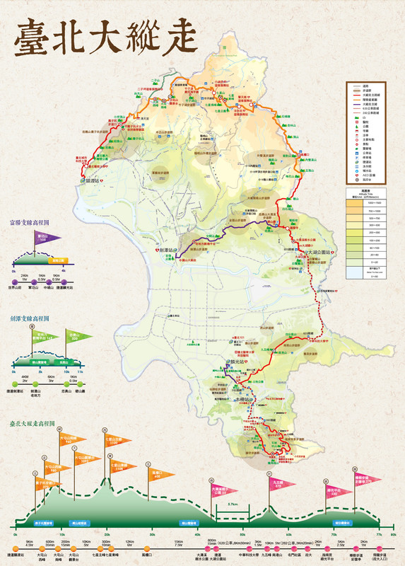
In September 2018, the Geotechnical Engineering Office of the Public Works Department of Taipei City Government announced the opening of the Taipei Grand Hike. This is a 92km route through some of Taipei’s most scenic landscape and over some of its most popular peaks. The hike takes in existing trails and roads, but new signs and facilities have been installed along the route to make sure that hikers can comfortably access the landscape. As well as covering a total distance of 92km, there is an elevation differential of 1120m, and according to the information on the trail’s official map you are likely to burn off upwards of 38,000 calories in the process of covering the miles.
Anyone wishing to pick up a map of the whole route can head to the GEO office during office hours at: 3rd Fl., No. 300, Songde Rd. (松德路), Xinyi Dist., Taipei City. (It would be great if these maps were more widely available.)
The whole route walk is split into seven hikes in two distinct areas, and these are linked by cycle routes. Five days are spent in the “Northern Taiwan Mountain Range”, and two are allocated to the “Southern District Tea Township”. Having said that, it would also be possible to split the whole thing into a larger number of shorter walks if you feel that spending 6-7 hours hiking at a time is too much.
NORTHERN TAIPEI MOUNTAIN RANGE – DAY 1
GUANDU MRT STATION to ERZIPING

The first part of the Taipei Grand Hike has you putting in some serious legwork to make it all the way from the flat land of Guandu right up into Yangmingshan National Park. This section takes in art, grand tombs, an irrigation canal, and many, many steps.
NORTHERN TAIPEI MOUNTAIN RANGE – DAY 2
ERZIPING to XIAOYOUKENG via DATUN SHAN
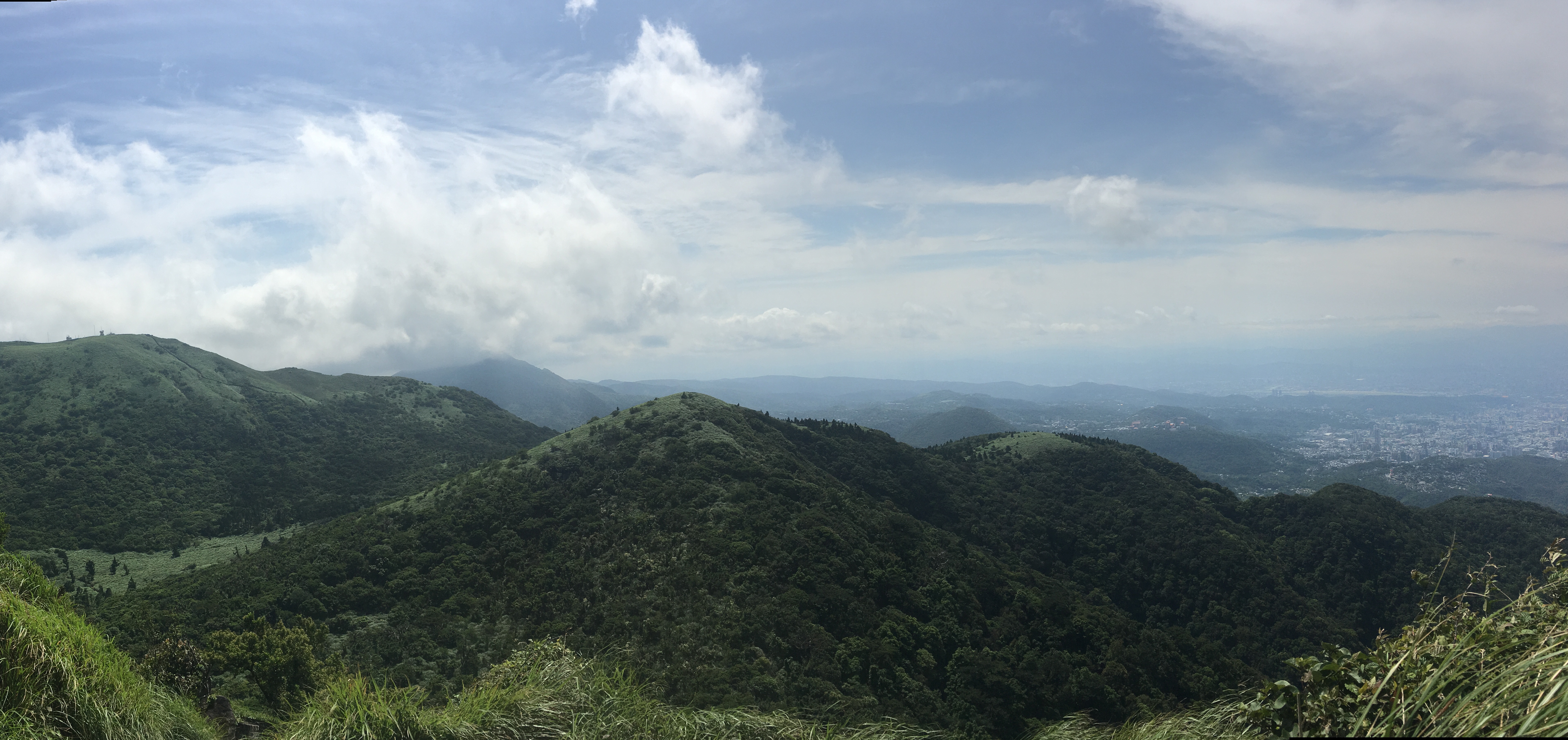
The second leg of the Taipei Grand Hike climbs some of the wilder peaks in the west of Yangmingshan National Park. This section starts from Erziping and takes in three peaks on the Datun Multi-Peak Trail before dipping down into the picturesque scenery of Dinghu. Then finishes by climbing along a stream to the steaming crater of Xioayoukeng.
NORTHERN TAIPEI MOUNTAIN RANGE – DAY 3
FENG GUI ZUI to XIAOYOUKENG via QIXING SHAN

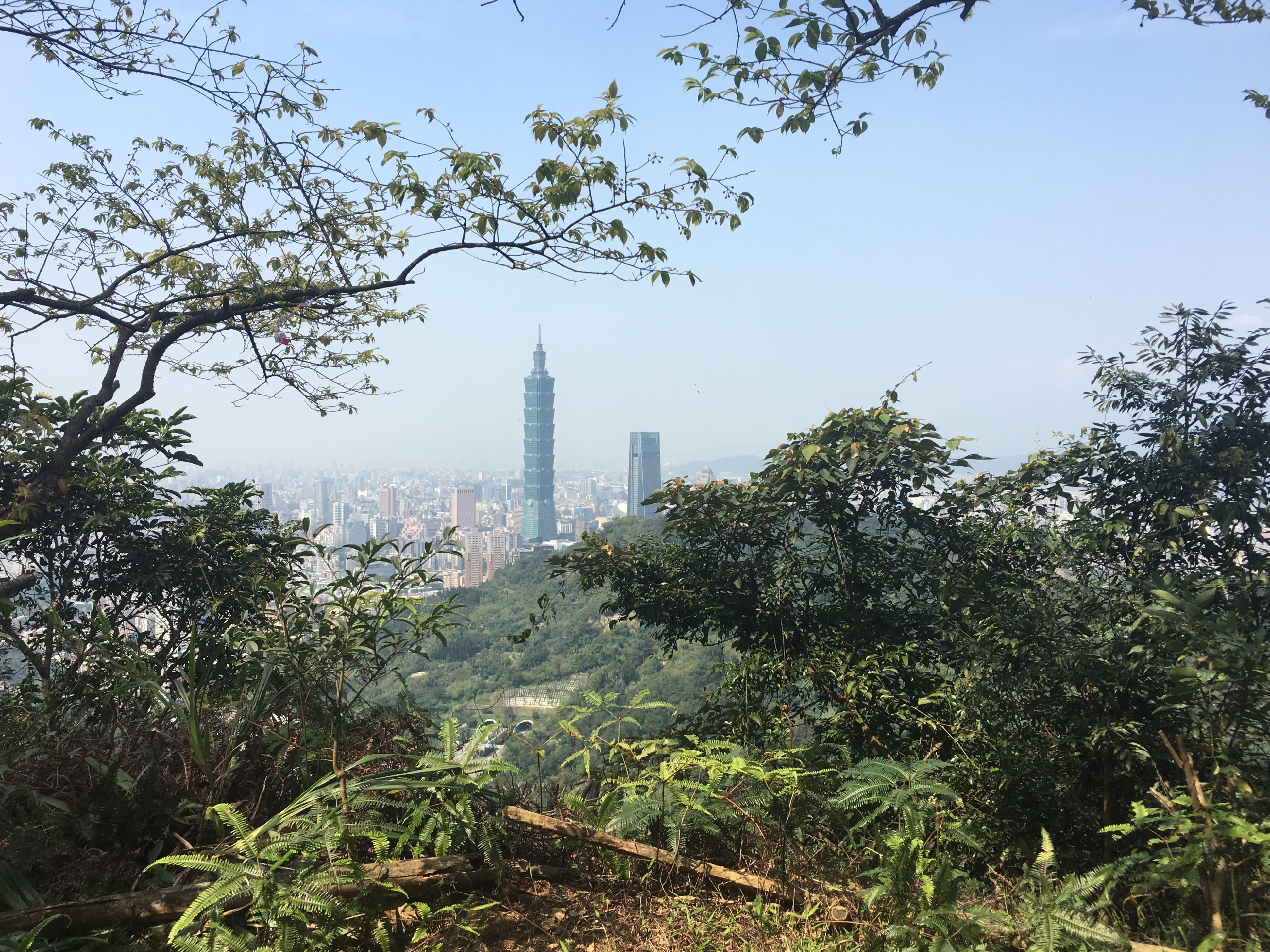
The third installment of the TGH has you climbing to the highest peak inside Taipei City. Go on a clear day and your effort will be handsomely rewarded with 360-degree views of the surrounding area. As well as big views, this route also takes in some really pleasant forest and ridge scenery on the Mount Ding – Mount Shiti Trail.
NORTHERN TAIPEI MOUNTAIN RANGE – DAY 4
FENG GUI ZUI to DAHU MRT STATION

The fourth installment of the Taipei Grand Hike takes you to some beautiful and quiet corners of Yangmingshan National Park, as well as some of the more popular scenic spots in Neihu. The best thing about this portion is that it has an abundance of water, from the natural and charming stream running alongside Shuangxigou Old Trail, to the manmade Sweet Water Lake, and the easily accessible Yuanjue waterfall.
NORTHERN TAIPEI MOUNTAIN RANGE – DAY 5
BISHANYAN to JIANTAN MRT STATION

Bisecting the northern and southern portions of the hike, day five takes you along the hills that separate Shilin and Songshan Districts. Here you’ll pass a supposedly haunted temple, the best spot for overlooking Songshan airport, and remnants of Taipei’s military past.
SOUTHERN TAIPEI TEA GROWING REGION – DAY 1
NANGANG SHAN to LIUGANG MRT STATION via TIAOMI OLD TRAIL
The Taipei Grand Hike’s southern arm stretches over the peaks of the Nangang mountain range and up to the huge temples and tea plantations of Muzha. In this section, you will experience wonderful views over Taipei, some of the most popular trails in the city as well as some much quieter, less frequented routes. Take in 360 degree views, historic trails, a mountain-side cemetery and a whole load of temples. This walk is a great way to start your Taipei Grand Hike adventure.
SOUTHERN TAIPEI TEA GROWING REGION – DAY 2
ZHINAN TEMPLE to MAOKONG and ZHANGSHAN TEMPLE
Section seven of Taipei’s long-distance path leads you up into the tea-growing hills of Muzha. There’s a waterfall, one of Taiwan’s top 100 religious sites, (Chihnan Temple), and the opportunity to take a rest stop in one of Maokong’s famous tea houses.
TAIPEI GRAND TRAIL +1
CYCLING from WENSHAN to GUANDU

Back when the Taipei Grand Hike was first announced, I was excited by the idea of a Taiwanese long-distance trail, but it always rankled that the trail didn’t encircle the city entirely. Well now it does. (Almost.) This post connects the end of section seven with the start of section one by following Jingmei River until it connects with Xindian River, then tracing that downstream, nipping across the narrow neck of Shezi Island and transferring to the Keelung River until that eventually empties out into Tamsui River around Guandu.
This is currently an unpaid side passion project and I will continue doing it just for the love of it, but of course if you like what I do and feel inclined to chip in a few dollars for transport and time then I would appreciate it immensely. You can find me on either Ko-fi or Buy Me a Coffee.

Thanks for putting this together. I am not Taiwanese so I didn’t qualify for the towel. When I saw the program I was surprised I had done many of the trails. This will help me tackle the rest on my next visit
LikeLike
I’m glad you found it interesting. Yes, a lot of the paths are ones which run along existing popular trails, (I’d done maybe about 40-50% myself before setting off to complete the whole route). I’m not sure if the towel thing is open to only people with Taiwanese ID or not, but it’s only valid for the first year of the trail’s existence. When I went back to the office they said that I was the third foreigner to have completed the walk. Anyway, I hope you enjoy your walking when you make your way back over here!
LikeLike
I love reading your blogs here as we definitely want to hike the 鳶嘴稍來山 Trail in Tai Chung after reading what you wrote as well as all these other wonderful shared Hiking journeys of yours…I will be traveling with my gf to Taiwan late March 2020 and we here in Vancouver BC Canada have two Facebook Hiking groups ie. iHIKE or Greater Hike Near Vancouver that many foreign visitors use to search out posts of local people organizing hikes on almost daily or weekly basis… of course, gasoline and cost associating are shared…and also an opportunity to share multiculturalism…is there such a Taiwan Facebook Hiking group for like minded hikers and visitors?..I can speak Mandarin fluently and not necessarily we need English guide to show us what to do but would be happy to meet and make local friendly hikers who we can tag along and hike with…please kindly advise.
LikeLike
Hi Eric, thanks for the message, and I’m very happy to hear that you’ve been inspired to hike some of the places I’ve mentioned.
As far as Facebook groups or other networks for arranging hikes, here are the resources I have found:
魔境熊登山客 & 登山自組健行隊. The second one seems like a place for ppl to show off. But a ton of members. (Recommened by @OutRecording on Twitter.)
http://xn--fiq43lo0ekydj26b7g4b.tw/?%E8%81%AF%E7%B9%AB%E6%88%91%E5%80%91,2 and https://m.facebook.com/CTMA.org/ (From @AnushaHiking)
https://m.facebook.com/groups/856785334467647/?ref=share and https://m.facebook.com/groups/188047991255790/?ref=share (Suggested by my partner.)
All of these would probably require some degree of written Chinese comprehension. If you need to read English, the only one that I am aware of is something like the meet-up group: https://www.meetup.com/Taipei-Hikers/
Finally, you could post on Forumosa (a Taiwan based forum which is mostly used by expats), maybe in the travel section and see if anyone wants to plan an outing together: https://tw.forumosa.com/c/travel
A note on how local hiking groups work here. Many of them are location specific, (as in the people all come from the same place, rather than they only hike in one place), and they tend to post a calendar of events which people can sign up to. As far as I know, you don’t need to become a group member to join one of their events, but I’ve never really joined one myself so I can’t be sure. However, Taiwanese people tend to be very hospitable to westerners, so I am confident that you should be able to find some people to walk with whilst you’re here.
I’m sorry I don’t really have any more relevant person experience to draw on. I hope the above helps though.
LikeLike
Thank you so much for all the information.
LikeLiked by 1 person
Hello, I am currently trying in Taiwan and plan to do sections of this hike.
As far as accommodation goes, are there places to stay at the end of each section? Camping and hostels?
And are there places to resupply food at the end of each section?
LikeLiked by 1 person
This route can easily be done by staying in the centre of Taipei and getting to and from the trailhead using public transport. In fact, I would certainly advise you to do it this way instead of trying to book several different places and carrying all of your stuff around with you. Staying somewhere central along the red line would be ideal. It gives you access to all of the food options of the city, and gives greater flexibility in the event that a day gets rained out, which is a high possibility if you’re planning on walking it this month.
There is one campsite (Bishan Campsite) that’s kind of along the route. However, the food options there are limited/non existent and it must be booked 7-30 days in advance of your visit.
LikeLike
I’m a beginner at hiking and undertook three hikes during my trip to Taipei, using the directions you’ve provided.
Thanks very much for publishing this website and including all the details for navigation. I look forward to referencing your website again for my next trip.
LikeLike
Hi Keith, thank you so much for letting me know that you found the site useful, it really means a lot to me when I hear that. I’m also glad that you enjoyed your hiking in Taiwan – I wonder which trails you did?
LikeLike
Hi, yes your website is very informative both the narrative and pictures/signage.
I did old Tianmu trail up to the University, Jian tan trail to Jian nan station, Zhinan temple steps to Maokong gondola and also the Zhishan stroll. I hope to be able to use your site for more trails in my next visit. Thanks again!
LikeLiked by 1 person
It sounds like you really got around the city! Luckily there are still plenty more places to be explored next time.
LikeLike
Great info here. Ta. Do you know anything about doing the whole trail in one go, without having to come down each day? Are there any campgrounds, guesthouses, is camping even allowed on the trail? Cheers.
LikeLiked by 1 person
As far as I’m aware, the only campground along the way is the one at Bishanyan. Foreigners in Taiwan have written about that here: https://www.foreignersintaiwan.com/blog-370963385326684/bishan-campground-and-bishan-temple
Apart from that it is necessary to return to the city between walks.
However, if you’re looking for longer walks with options for camping or sleeping at B&Bs along the way, then you might want to look at the walking the Tamsui-Kavalan Trails. These are multiple trails connecting Taipei with Yilan, all of which have plenty of options for stopping along the way. I’ve just finished my write up of all the walks here: https://taiwantrailsandtales.wordpress.com/tamsui-kavalan-trails/
Have fun walking!
LikeLike
Thanks for that. I’ll read your article.
LikeLike
May I ask which app you used to record your hike?
Also, just to clarify, as a foreigner, did you receive the gifts and certificate after you finished?
LikeLike
I used View Ranger to record my walk, (it’s since merged with Outdoor Active), and instead chose to supply photos of myself at each post as proof of my walk. It’s also possible to record your walks using the 健行筆記 app, but the interface isn’t too intuitive if you’re not used to reading Chinese.
And yes, I did get the certificate and a towel upon completion. I asked, and I think they said maybe seven or eight other foreigners had registered that they had completed the walk prior to me.
LikeLike
Hi, may I clarify. Will the walk recording in view ranger app be sufficient proof that you completed the trail? I’m not sure, I read somewhere you have to take selfies with some Qr codes along the trail. Thank you!
LikeLike
Hi there, sorry, I didn’t see your message come in. You don’t need to use ViewRanger at all (actually you can’t, the app was discontinued). However, if you want the towel and completion certificate then you will need to download the Hiking Biji app and use that to record you walks. It’s all in Chinese, but I can refer you to this wonderfully thorough and illustrated explanation of how it works: https://www.facebook.com/groups/Taipeihikers/permalink/2040768899439307/
LikeLike
What is the furthest a person has hiked in one go?
LikeLike
This news story seems to suggest that people have been able to complete the whole thing (minus the visit to Erziping) within 24 hours. I’m not sure I would recommend it though!
https://udn.com/news/story/12395/6647356
LikeLike