
Distance: 7.6km (station to station)
Time: 3¼ hours – Including time getting to and from the station.
Difficulty (regular Taiwan hiker): 1.5/10 – Lots of steps and lots of different ways to go but that’s it.
Difficulty (new Taiwan hiker): 4.5/10 – (Either the harder end of easy or the very easy end of moderate) – This is the easy route up to Nangang Shan, it’s all paved and easy-ish to follow if you stick to the main trail. It’s a little steep in sections and the distance makes it a little harder than just Xiangshan, however as long as you’ve got enough water, and some snacks it should be no problem, (also sun cream or an umbrella if you go in the summer).
Total ascent: 506m
Water: 1.5L – In summer, I only took a little over 1L and it wasn’t quite enough on a hot day, but you should find 1L is sufficient if you’re not sweating out your own body weight in water.
Shade: patchy – I used an umbrella much of the way.
Mobile network: Mostly good with a few, brief blackspots.
Enjoyment: The route I took was the easy route so it was paved the whole way, I think some of the side-paths looked like they’d be more fun but I wouldn’t fancy attempting them in this weather. The variety of temples and shrines made up for the not-so-exciting walking. This area has a huge wealth of trails and a similarly huge number of blogs detailing different paths (like here, here, here and here) so take your time to check which one you think you’d enjoy. Also, there are those iconic views of Taipei 101 to take in. For a convenient city walk this is definitely worth the effort.
Other: As with many mountains in Taiwan, these go by three names, elephant mountain goes by its pinyin name of xiang shan or the Chinese characters 象山, thumb mountain’s pinyin is muzhi shan, the characters are 拇指山 and 95 peak is also known as jiuwu feng or 九五峰 – you’ll find them referred to as all of these different names on different signs and maps along the trail.
Map:

Link to a downloadable version here. Also, there’s this map of all the routes in the area.

Starting at Yongchun station, take exit 4 onto Taipei-Keelung Main Road.

Turn right onto Songshan Street and keep going straight, (ignore Songde Road, just go over it).

Cross over Fude Street and on the other side veer right onto Alley 3, Lane 76.

Cross over one road and at the next junction turn left onto Alley 8, Lane 76. Follow this road until you arrive at the trail head.

The path starts right next to Songyu Fude Temple (松友福德宮).

More accurately, the trail starts through the temple. A woman was sat under the shade of the temple awning reading a newspaper and a water dispenser which had 奉茶/fèng chá written on the front – Teresa late told me that this is an old way of writing ‘please drink’. Right next to the temple are the old remains of another temple, this one dedicated to Yan Hui lay abandoned – the building is relatively modern (it was built in 1975), but has already fallen into disrepair.

There’s a short, steep set of stairs to get you in the mood before the path levels out briefly at Youchungang Park. Go straight through following signs for Xiangshan hiking trail.

At the far end of the park take the path up towards Xiangshan.

You’ll pass an electricity pylon and a couple of graves.

Skinks and tree lizards darted left and right as I climbed up – they were decidedly more active than the other locals I passed, this collection of uncles mustered just enough strength to shout hello and then congratulate themselves on their English abilities.

Right from the start this walk starts to show you what it’s all about: big wide views of the city – this rest point looks out over Nangang. Given that this is prime tourist territory, the English is pretty good on all the signs – that’s how I came to know that this vista used to have a pond which has long been drained. According to local tales, the surrounding mountains were given their names (elephant, tiger, lion and leopard), because from a distance the mountains were said to resemble these animals gathered around the watering hole of Yongchun pond.

With your back to the view of the ghost of Yongchun pond, the steps continue upwards.

There were many uncles in this area, mostly demonstrating their physical prowess and age-defying leanness. The above junction is where this route intersects with the more populated path up Xiangshan, and to the right is the much-photographed view that you’ll find in all the guide books, (the one with those famous boulders that you see in nearly every single post on the subject – that last linked photo is rather good). I’d walked up that way sometime last year, before I moved here. It’s always strange to revisit places after a big change in circumstances, the last time I came Teresa was still walking with crutches, we’ve both made improvements to our physical health since then.
I went left following a sign which indicated that it was another 30 minutes to Muzhi mountain (it took me 40 minutes), and 45 to Wufen Mountain but I think that time is for the direct route which bypasses Muzhi.

There are a few junctions with limited signage, just keep a look out for anything heading towards Muzhi.

Along this section of the path I could hear the sounds of Buddhist music crossing the mountains from Ci Hui Tang (慈惠堂), another one of the many temples in the area. Through a gap in the trees it’s also possible to spot wenshan tunnel disappearing into the side of the hill.

A bend with steps leading up is the sign that you’re approaching the next point of interest. Ignore the steps (they just go up and come down again around the other side of the mound).

The path runs just above and behind another buddhist temple, Cisheng Gong (慈聖宮) – and this one has a garden for the Guanyin bodhisattva.

I went down to get a better look at the goddess and the other statues surrounding her. Two lions flanked her and an impish child buddha statue seemed to be offering something to her. On the table in the garden, game pieces for Chinese dark chess had been left out.

Getting back on the path I continued around the bend, leaving Guanyin behind.

At the next intersection ignore the steps going up and follow the directions to Jiuwu Peak (九五峰) and Muzhi mountain (拇指山) – it seems the English writing on the signs briefly disappears here but it comes back again later.

Another diversion on the right heads towards Ci Hui Tang, the source of the music I’d been hearing for 30 minutes – keep going straight through on the last 570m to Wuzhi mountain.
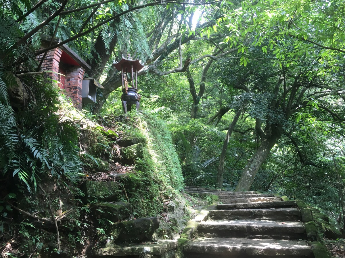
The trail passes a small, red brick Tudi Gong shrine, incense lit and the land God sheltering within. The steps just beyond this point are different to the rest of the trail, they seem to be made of a softer, more aesthetically pleasing sandstone which had been worn down by the passage of so many feet.

At the next compass junction head up the steps towards Muzhi Mountain, just another 190m – the smaller path going straight heads to Muzha (木柵, spelt Mucha on the sign). These four-point stars are at all the major intersections inscribed with 東, 西, 南, 北, (west, east, south, north – that’s the order they say them in here, it feels really weird), I hadn’t realised until this point that they were for this purpose.

The path arrives at Muzhi scenic area before the top of the hill itself. When I got there, there was only me and a small scurry of squirrels taking in the view, (actually, I think I was the only one taking in the view, the squirrels seemed altogether more concerned with whether or not I had anything they could eat). The lookout faces towards the northwest over Xinyi and Da’an district. A thermometer stuck to a tree told me that it was 34°C. Continuing up I passed the top of Muzhi Mountain off on a short spur to the right – I had a brief amble up the steps but returned onto the main path to continue on to Nangang shan.

There was another shrine, this one built into the wall of a cliff. Looking up it seemed that there might have been an awning at one point but not any more. The set up of this shrine was different to other shrines I’ve seen, maybe more like some I saw in Hong Kong. The five deities were lined up against the wall and a pack of guardian lions were placed in a smaller alcove below the main alter. To the left of the shrine there was also a plaque on the wall with an incense holder which seemed to be dedicated to a Chinese general. I asked Teresa what the plaques on the main wall were – she said they looked to be mostly names of the Gods who were worshipped there.

Moving up, I spotted one of the highlights of my walk, in a nook in the side of a rock I saw a lizard sitting watch over a clutch of small white eggs. I’ve never been lucky enough to actually see this before so I was really excited. She watched me cautiously as I took her photo and I tried to be quick so as not to disturb her too much.

If you look at a map it’s possible to see a little spike in the loop around Muzhi mountain where the path seems to dogleg back on itself. That’s the point in the above photo, route maps suggest that it’s a crossroads with five possible routes, but only one is paved so it’s easy to know where you’re going. 600m from here up to Jiuwu peak.

I stopped for a drink at a viewing platform, there was a woman there who’d also stopped, she was on her way down though. She asked me where I’d walked from and then she made sure I had enough water to continue on. I could see where I’d started almost hidden behind the ridge of elephant mountain that I’d climbed an hour or so earlier. The red rooftops of temples stood out amongst all the greenery, one I’d passed earlier (the one with Guanyin’s garden), and another that I hadn’t seen.

Leaving the viewing platform I saw an arrow pointing down the side of a fence post.

Looking down revealed a vertiginous roped route heading almost vertically down. It seems these hills are laced with such paths, infinitely more challenging than the paved ones. I’d love to go back and do Jiuwu peak the hard way!
(EDIT: I did go back and do a few of these, they were great. However they have unfortunately now been closed due to accidents.)

The 375m Nangang mountain transpired to be perhaps one of the dullest peaks I’ve ever visited, so dull in fact that I’m surprised that trail bears its name. The trig point was boxed in on three sides by a wire fence because of its proximity to a television broadcast tower. Just beyond the top there was a service goods cable car and beyond that there was a closed toilet block.

Just a short way from Nangang Mountain top is the red-marked stone which lets walkers know they’ve arrived at Jiuwu peak. I hung around for a quick snack but pressed on when I noticed just how heavy and grey the clouds had become.

Heading down, the good views continued, going north you can look out towards the hills of Yangmingshan National Park.

Just off the path to the right there was another shrine – hidden beyond this building was a small garden with lots of picnic tables.

There are a few paths branching off (mostly to the right) but just ignore them and keep heading straight and northwards.

There are more shrines along the way, each with their own character – this one was built under the shelter of large slab of rock.

At the next junction continue straight, passing through a small exercise area.

I chose to head down at the junction in the picture here since I was nearly out of water, (signposted towards Beixing Temple). If I’d been better prepared I would have continued on (towards China Institute of Technology).

Before going down though I had a quick look at the Land God Temple just beyond the junction. It seemed better kept than some of passed on this path, the paint on the dragons was still bright.

There was just one more shrine on the path before I reached the exit, this one seemingly moulded out of the rocks and concrete, it looked a little strange compared to the more traditional shrines.

At the bottom, the trail heads down passed Beixing Temple on the left and I went north on Chengfu Road.

At the junction with lane 178 I crossed over and turned left, passing the park and a swimming pool on my right. (If you go in the summer you might want to take a change of clothes and a towel and have a quick trip to the pool to shower and change.) Following this lane around eventually brings you to Houshanpi Station.
How to get there:
Google maps address: 松友福德宮 trail entrance, 110, Taipei City, Xinyi District, Alley 8, Lane 76, Section 6, Xinyi Road, 41號
GPS location: N25 01.933 E121 34.563
Public transport: take exit 4 from Yongchun MRT station (blue line), and return via Houshanpi station (also blue line)
My new words learnt on this walk were:
- 獅子 / shīzi / lion
- 拇指 / mǔzhǐ / thumb
- 我的那個 / wǒ de nàgè / my period -this is kind of euphemistic, similar to my time of the month in English. “我現在有點累因為我的那個來了” – “I’m a little tired at the moment because it’s my time of the month.”
- 在雨中 / zài yǔzhōng / in the rain

Pingback: xin shan to meng hu and kezilin river pool (新山, 夢湖, 柯子林天然游泳池) | taiwan trails and tales