
NOTE: This post has been superseded with a newer version that does not involve breaking any rules. I have decided to keep this old post here just because it covers slightly different ground, but for a better planning resource, make sure to read this updated write-up of the Stegosaurus Ridge Hike.
Distance: 9km
Time: 8½ hours – If you’re coming in a group with a couple of cars it would be feasible to cut it down to a 6-hour one-way walk stopping just after Teapot Mountain.
Difficulty (regular Taiwan hiker): 4.5/10 – Steep and taxing in parts, but those parts are relatively short.
Difficulty (new Taiwan hiker): 8/10 – It is a mentally and physically taxing route and whilst it’s not as physically challenging as something like Wuliaojian, the added element of risk means that you are kept extremely busy with the mental task of keeping yourself from slipping or falling. Apart from the very last section through the village, there was barely a moment where you could forget about where you were putting your feet and hands.
Water: 1.5L – It’s long, between the two of us we took about 3L and we drank almost all of it. If you now out after Teapot Mountain there are places to grab some water near the bus stop that heads back toward Taipei.
Shade: almost none – despite regular applications of sun cream and pretty constant cloud cover I am now sporting a definite pink hue on the right side of my face, (the consequence of walking northeast to southwest on an exposed ridge). The locals I encountered didn’t seem to share my misfortune but my hiking companion suffered minor ill effects from such prolonged exposure to the sun later in the evening. This hike is definitely weather-dependent, no rain, no wind, and if you’re sensitive to the sun you’ll want to go on a rain-free, wind-free cloudy day.
Mobile network: Whenever I took out my phone the signal seemed strong, but for most of the walk my phone was safely stashed away where it couldn’t fall to its doom.
Enjoyment: I was nervous about doing this hike, as I’ve said before on this blog, I treat such environments as places which should be approached with great respect and caution, but I am so glad that I did it. The views are unbelievable, I frequently felt overwhelmed by the beauty in front of me and the exhilaration I felt after conquering my fears to scale this ridge was amazing.
Other: Technically this walk is not really legal, or at least some versions of it aren’t. The entrance bears a sign forbidding entry, (blog post on that can be found on the off the beaten track website), and whilst I haven’t heard of anyone prosecuted for attempting this, it’s something that everyone has to weigh up for themselves before they decide to go. Also, we accidentally found ourselves in a second prohibited area when we walked from Teapot Mountain back down to the village – the top of the trail has nothing to indicate that it’s off limits, however, the gate at the bottom end makes that very clear. And there’s good reason for this area being out of bounds, as the site of an abandoned mine, the ground and water has high levels of toxic heavy metals so it’s definitely not somewhere that you should stop to have a picnic. And in case you hadn’t got the message already, this is a risky walk – it needs good weather, an early start, enough food and water, appropriate clothing: gloves, long sleeves, long trousers and shoes with decent grip, (we met a few guys doing it topless but they ended up covered in scratches from the shrubbery and rocks). A lot of the other hikers had brought hiking poles with them but for the ridge part of the walk they were more hindrance than help – everyone strapped them to their packs and more than once I had to duck to avoid getting a spike in my eye, you’d be much better off with gloves. Finally, I definitely wouldn’t advise doing this alone.

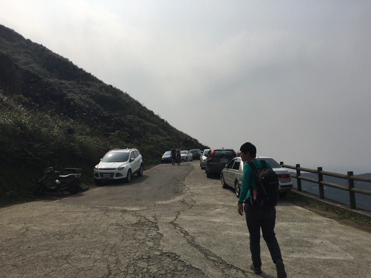
Having prepared everything the day before, we were out early and arrived at the trailhead at 8am. As it was a Sunday there were already plenty of others who had either just set off or were preparing to set off on the walk so we started the walk along with a hiking group. The path dives around the side of a large monument type of thing.

Immediately there is a sign warning hikers against continuing. It’s worth noting again, anyone doing this is doing so in knowledge of the fact that it’s technically not legal. (Although as mentioned in the blog I linked to, it seems there is a more legitimate route going from near the 80.1 road marker just beyond the other end of the factory complex, so perhaps you don’t need to come past such alarming signs).

Buoyed on by the fact that we were part of a big crowd we started out skirting the edge of an abandoned factory complex.

The path darts along to the left of the brick wall and just where the wall finishes we veered right to a more open area where we could cross the stream.

Just the other side of the water we headed to the left towards the rear of the factory complex.

We passed another empty building, this one was literally just a shell, everything had been stripped out of the interior, not even any glass remained. There was a lift shaft, open to the elements, the door must have come off years ago, but a rusting suspended floor was waiting at ground level like an invitation to so much pain.

Past the last building the paved road peters out and becomes a seriously overgrown path zigzagging up the hill towards another concrete shell.

A few of the group who has set off ahead of us were posing for photos in the weird structure – this was an act that all of the members of the group repeated ad nauseum for the entirety of the hike – often in a way which blocked the path and caused long tailbacks.

This next section (as well as some of the parts later on), was characterised by tall, exuberantly growing grasses, it’s not exactly that it was overgrown – there was a clear path to follow at all times – more that not enough people come this way to stunt the new growth.

At 1km in and as the path comes up against the base of stegosaurus ridge there is a T-junction where we had to turn left in the direction of all the plastic tags, (the right hand path isn’t tagged and doesn’t seem to go anywhere).

Less than five minutes from the T-junction we met a crossroads, the right hand path was the one we took, heading directly up towards stegosaurus ridge, (signposted 往劍龍稜). The left hand path is a short scramble up a small peak where it is possible to get a good view of those ahead of you starting their climb.

By this point, the blood pumping through my legs had managed to dispel most of my worries about what lay ahead and had replaced them with excitement. The picture above was taken at a little staging post right before the serious climb starts.

People were stopping there to selfie (again), consider the route ahead and admire the view back to where we’d started.

But we couldn’t stop too long and soon the upwards push began. It wasn’t nearly as terrifying as I had imagined – the angle of the rocks means that it’s pretty easy to have three points of contact at all times if you’re as safety obsessed as I am, and as long as your back is well balanced and tightly attached, (and you exercise due caution), it should be easy enough to navigate safety. I don’t really like heights all that much and have a tendency to feel a little nauseous in situations where there isn’t enough separating me from a large drop, but on this occasion good preparation, awareness of what to expect and feeling relatively confident in my ability to do it meant that it was thrilling rather than terrifying. From quite early on in the walk it’s possible to spot where you’re headed, the ridgeway curves majestically around towards the distant, curiously shaped knob of teapot mountain.

This is the view looking back – on the right is the ridge we’d just come over and to the left it’s just possible to make out the discoloured stream water spilling out into 陰陽海 (the ying and yang sea). If you click to enlarge this picture you’ll see one of the other hikers posing for another selfie on the ridge, by this point in the walk Teresa had become thoroughly fed up with their loudness, up-your-backsideness, extreme friendliness and incessant selfie taking/posed group shots (which we were roped into). I’m a little more tolerant than her since I became a hiker in Hong Kong where it is virtually impossible to find somewhere totally quiet even when you’re in the mountains, but even so, it had started to grate on me too. There were a few of the male members of the group who took unnecessary risks to get the photos they wanted, others who didn’t seem to care about the precariousness of the route as they over or undertook – at several points I saw stupid decisions and careless behaviour cause slips, fortunately they were only small but that’s beside the point, they could have been a lot more serious and I was annoyed with them for being so selfish – their misfortune could have turned into misfortune for everyone there. Also, their photo breaks totally blocked the path and I lost track of the number of times that we were stuck waiting behind someone who was trying to find the best angle for a picture. I understand that people want to get photos of such beautiful landscape but I just wish it could be done with a little more consideration (and a little less frequency).

Once you’re up on the ridge there aren’t really many places for you to go wrong, you can see your destination and it’s simple enough to follow the path along the ridge. At one point there was a junction in a small grassy clearing (which I failed to photograph because the group had stopped there for a snack break and we wanted to keep going to get a little way ahead), I think there might have been another path but we just continued left following the same ridge.

Just after the last really ridgey ridge part and shortly before the highest point and the path climbs up the side of the peak before it sneaks up to the top to give you a slightly closer view of the teapot mountain sitting in front of Keelung mountain.

This was 4½ hours and almost 3km into the walk – at this point it was possible to continue on for another 10 minutes towards banping shan (半屏山), or head directly down towards teapot mountain. Since most of the group were heading on towards banping shan we thought we’d try to get a little way ahead by heading straight down.

Despite it seeming so close, it still took almost 30 minutes to make our way to the teapot. Along this stretch we passed a lot of people coming towards us, many of whom seemed not quite properly equipped for a big hike.

As we rested in the shade of the teapot the group caught up with us and had a final chat before they got back in their cars to return them to the start or head on for refreshments at one of the nearby villages. From the teapot you have a good view of Jianguanszi to the northeast and the huge Ruifang District ninth cemetery on the hill beyond the village. Just over the crest of the hill behind the cemetery is tourist town Jiufen. Our route forward from her took us through the middle of the teapot, (I’m never going to enjoy being in a rock shaft under a huge rock in a hiker traffic jam), as we came out the other side there was a big party of high school students all wearing uniforms and name tags around their necks – members of the hiking group proceeded to (incorrectly) shout out the names of all those they passed.

The next part of the walk was pretty straight forward, especially as we’d already done it before.

We kept heading down until the path rejoined the road.
At the road we turned left and headed down some more.

At the pavilion we took a short cut on the right, (the road zigzags back and forth but the steps are pretty straight).

The path crossed the road and continues down.

At this junction we went right, but if you’re planning to get back on public transport then you could head straight down into Jianguanszi and refuel a little before catching a bus home.

At the end of the path there is a parking space which would be perfect for anyone coming in a two-car convoy. But we were planning to walk the whole loops so we went to the right and then behind the viewing platform.
At first it seems like it might be a truck road.

And then it becomes a small dirt track.

And then eventually the plants threaten to swallow you whole. Again, there was actually a pretty easy to follow trail here but the overgrowth made it hard to see the floor. I was very grateful to be wearing long trousers and sleeves at this point.

The views to the right are of the valley running down from teapot mountain and parts of the disused mine.

This was the only point where the path became a little unclear, (just right of frame there was a possible path but it lead nowhere). Just beyond this we hit another T-junction where a much more defined path went up to the left and down to the right. We followed it right and downhill.

It was clear that other hikers had been here, but for today it was just ours. At this junction we headed right again.

Down some steps and right at the bottom of the steps. This is where we came out into the abandoned area proper.

We passed a gutted red brick building with political graffiti scrawled over one of the inner walls.

Just beyond the red brick building we joined the disused road. We kept on this until it ended, on the left we passed another abandoned building and a tunnel, we had a little look in the tunnel, it wasn’t that long and it seemed some hikers had used it as a route to somewhere as there was a trail tag hanging above the entrance.

At the end of the road there is a faint path leading down to another road.

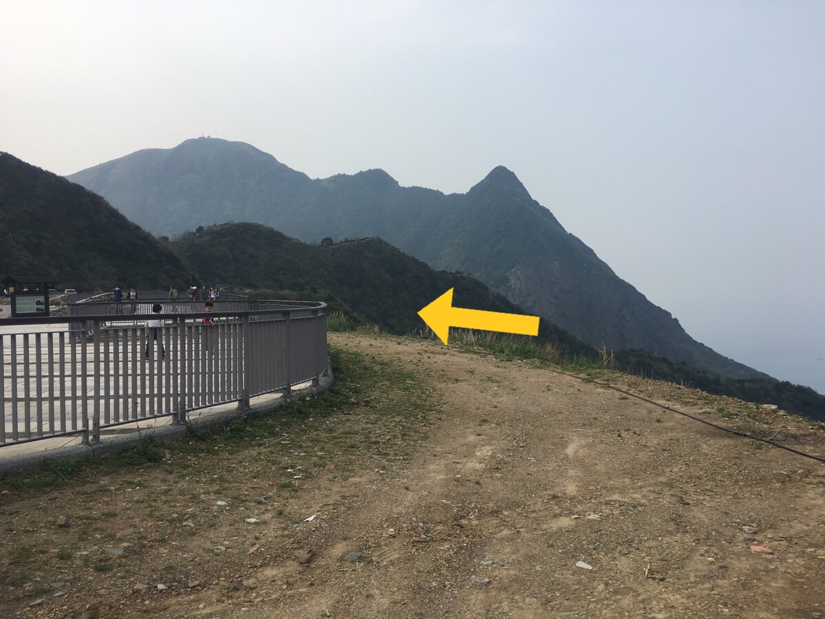
The route continues down the road but before heading down we decided to explore just up to the right where there was another clear path (blue arrow).

The sight just over the crest of the hill was amazing. Giant concrete worms stretched over the landscape like something out of a dystopian graphic novel, in places they had crumbled in on themselves leaving gaping holes open to the elements.
These tunnels are the remains of the flues which carried toxic fumes away from the copper refinery back in the days when it was still in use (until the 1980s), they took the dangerous fumes away and deposited them on the rear side of the mountain where there weren’t any people living. According to the information board on the road nearby (I have no idea why there was an information board there given that this place turned out to be a restricted area), high concentrations of harmful heavy metals remain in the concrete of the flues and the surrounding area and prolonged exposure should be avoided. There is a definite grotesque beauty in this sight, but at the same time it lays bare the ugly wounds that we are happy to inflict on the planet in our hunt for resources – the fact that this area is still considered too dangerous to enter as a result of how we humans failed to exercise proper care should be something that we learn from.

This was the point at which we realised that the path wasn’t quite a sanctioned one – there was a gate blocking the exit but in true Taiwanese style, hiking groups had made a path around the the gate, we just climbed up behind a tree and back down the other side. There is a sign on the gate warning that traps assets will be imprisoned or fined, and there’s also a big stone trail marker, (which I assume must predate the area being shut off). Once we’d gone around the gate we headed right towards the remains of some more buildings.

There were a lot of people admiring the view here, the ruins extend both up and down and whilst there are signs prohibiting entry, it is clear that not everyone has been deterred by them. We decided that we had broken enough rules for the day and followed the road round to the right past a coffee shop and a statue of a horse and down.

As the road meets more houses we took what I think must be a shortcut down some steps to the right.

There are a couple of junctions along the way but we basically just kept going downhill.

The path opens up again and we could see the sea, then the path goes right past some houses and it starts to feel like your on private property, (actually we did stumble onto private property by accident in our way down but we’re lucky enough to meet friendly people who simply pointed us back in the right direction).

Just beyond the building in the last picture we headed between brick walls and down to the yellow house.

It was a little tricky navigating through the houses but at least it’s easy enough to see where you’re headed. There was a large number of small kittens in this neighbourhood, just big enough to be a little independent but still seeming too small to be without their mum.

A lot of the houses in this area are either very run down or abandoned, and we saw a community full of mostly older people so I would imagine that it’ll only fall further into disrepair over time.

We turned left and down through a covered passageway ands aid hello to a trio of amas who had gathered to chat.

Around the last building and down brought us out next to an old basketball court where another grandma was walking laps.

Passing the basketball court on our left we headed through a pathway under the road.

Through the other side of the tunnel we emerged by the harbour and turned left to go up and join the road.

The last 20 minutes of the walk were done on the road, it’s not the nicest road to walk but at least the shoulder is pretty wide. It’s also worth keeping an eye out for the interesting rock formations on the left as you go past, they’re pretty cool.
How to get to Stegosaurus Ridge
Google maps address: 224, New Taipei City, Ruifang District, 北部濱海公路224號 this is the location where we started from – aparently people have started another path going from here, which bypasses the prohibited areas. We saw a group heading down this way when we were nearly back at the car. There’s space to park on the side of the road near the trail entrance but there seemed to be a police car taking note of license plates when we got back (no one spoke to us or took our plate number), so I guessing something to do at your own discretion.
GPS location: N25 07.334 E121 52.752
Public transport: the 1812 bus runs from Taipei Main Station towards Nanfang-ao to here, you can get out at 水湳洞 which is right outside the abandoned copper factory. If you did this you’d have to do the road walking section first. Also this bus doesn’t start early so it’s not necessarily ideal. Alternatively, if you’re coming from Keelung there is a direct (if slow), bus from here, the 791 will get you to near where we started.
My new words learnt on this hike were:
- 天鵝 / tiān é / swan
- 腳趾頭 / jiǎozhǐ tóu / toes
- 手指頭 / shǒuzhǐ tóu / fingers
- 砷 / shēn / arsenic
- 銅 / tóng / copper

Beautiful! Informative and exhilarating to read – how exciting to actually make the climb. Thanks for the virtual hike.
LikeLiked by 1 person
I’m glad you enjoyed it. I enjoyed looking at one of your explorations too.
LikeLike
I have to admit that you do a great job on giving directions to Stegosaurus Ridge. I love the hike personally, and without the pictures I think it could be a bit difficult finding this place. Thank you for your help.
LikeLike
Thanks for saying so. I would have had trouble too if I didn’t have a local parter to help. This is definitely one of the top hikes in northern Taiwan.
LikeLike
Pingback: 6 Last-Minute Taipei Hikes You Can Do in a Day - Taiwan Scene
Pingback: 6 Last-Minute Taipei Hikes You Can Do in a Day – Taiwan Scene
Hi hi there.. my husband and i are visiting Taiwan end of Dec and wld like to check regarding Stegosaurus ridge.
As it’s a point to point hike, shld we park our car at stegosaurus start point (nanzilin trail?) and take a taxi back to our car after the trek OR park our car at the end point at teapot mountain and take a taxi to the start of stegosaurus trail?
Which place would be easier to get a taxi? I’m really afraid we would end up stuck without any taxi.
I have tried googling for blogs regarding stegosaurus ridge but noticed that many are dated back to a few years ago.
LikeLike
Hi there. I think it would be best to park at the Nanzilin trailhead and then get a taxi back down. If you walk down from Teapot Mountain to Jinguashi Gold Museum (there are signposts and maps which will point you in the right direction), you should be able to get a taxi relatively easily.
Also, if you start early enough, you can make this into a big loop hike.
LikeLike
Thank you so much for your reply!
LikeLiked by 1 person